The Upper Basin includes
the states of Wyoming, Utah, Colorado, and New Mexico. The Lower
Basin includes Arizona, Nevada, and California. In 1922, these
seven states reached an agreement to divide the waters of the
Colorado River between them. The Colorado River Compact was
created.
Water developments, such
as dams and power plants, along the Colorado River and its
tributaries are the product of this arrangement. Water flows are
dictated by the Compact as well.
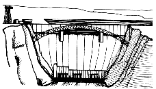
Glen Canyon Dam
Glen Canyon Dam was
authorized by Congress in 1956 to provide water storage in the
Upper Colorado River Basin. The result was Lake Powell, the
second largest man-made reservoir in the United States. (Lake
Mead is the largest.) It took seventeen years for the lake to
reach its full pool level of 3700 feet (1128m) above sea level.
Water flowing into Lake
Powell is derived primarily from snowmelt from the western slope
of the Rocky Mountains. Allocation of water to the Lower Basin
states is ensured by the release of water from Glen Canyon Dam.
Water releases are planned on a monthly basis to avoid high
water spills while benefiting recreation, power generation, and
fish and wildlife uses. 85% of the water goes to agricultural
production, and a relatively small amount is used in urban
areas.
Changes
Glen Canyon Dam has
created a new Colorado River. Before the dam was built, water
temperatures in the river fluctuated seasonally from 80°F (26°C)
in the summer to near freezing in the winter. Now, the water
temperature below the dam averages 46°F (7°C) year-round. The
Colorado River was once filled with silt and sediment. Now, the
river deposits its load of silt as it enters Lake Powell near
Hite, Utah. Water released from the dam is clear and the
Colorado River is muddy only when downstream tributaries
contribute sediment.
As the habitat has
changed, so have plant and animal species. Native fish, unable
to survive in the colder water, have left the river. Five
species are now endangered. But this new habitat now supports a
healthy trout population. Before Glen Canyon Dam, spring
run-offs built and rebuilt beaches and sandbars and scoured away
riverside vegetation. Now, sediment is trapped in Lake Powell
and the dam prevents high river flows. Riparian vegetation now
grows along river banks, creating habitat for mammals, birds,
amphibians, insects, and reptiles.